The Straight-Line Map Trap: Why Nearby Places Can Be Hard to Reach
The straight-line map trap shows why nearby places can be far apart in practice, helping you compare geographic distance with access to real destinations.
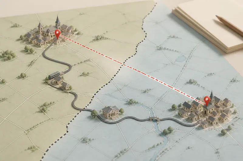
The straight-line map trap makes two nearby places look easier to connect than they may be. A map’s direct line measures geographic separation; it does not tell you how a boundary, uneven road network or misplaced endpoint shapes the journey.
That distinction matters when comparing settlements, services or administrative areas. Treat the line as a stable reference, then examine the connections that make one place part of another’s everyday orbit.
Straight-line distance describes location, not connection
A straight-line measurement is useful because it stays the same regardless of whether someone walks, drives or takes a train. It lets you compare the relative positions of places without assuming a particular route.
But a map’s dots and labels can make places seem more connected than they are. A boundary may separate local services or transport systems; a railway may serve one settlement but pass another without stopping. The map’s clean line records none of those relationships.
Think of the line as a piece of string stretched between two pins on a noticeboard. It shows where the pins sit, not whether a path joins them.
Boundaries can divide everyday connections
An administrative boundary can separate neighbouring communities that use different service areas, local networks or planning systems. The effect is not always a longer physical journey: it may instead mean that a nearby facility is outside someone’s usual school, health or council arrangements.
Look at the boundary alongside the names and functions of the places it divides. A regional line on a map may be less significant for a traveller than the location of a station, service centre or local authority office. Conversely, a boundary that appears faint can matter greatly if it determines which services are available.
Say you are comparing two villages on opposite sides of a county line. The map shows their centres close together, but a resident of one village may use a service hub in a different direction because local arrangements attach the village to that hub. The useful comparison is not simply which centre is nearest; it is which centre serves the village and how people reach it.
Settlement centres are not always useful endpoints
A map label can stand for a broad built-up area, while a measurement tool needs a specific point. Choosing the label’s centre may distort a comparison when the station, school or civic building lies near the edge of the settlement.
For a meaningful comparison, name the actual origin and destination. A journey from a village hall to a railway station answers a clearer question than a line between two settlement names. This also helps distinguish a place’s geographic closeness from its practical relationship with a neighbouring town.
Check whether the map uses a town-centre marker, a postcode, a building entrance or a broad settlement boundary. Those choices can change the apparent distance without changing the places themselves.
Compare distance with the relationship you want to understand
Different questions call for different comparisons. A geographer describing relative location may need straight-line distance; someone studying commuting patterns may need actual destinations and transport connections. Neither measure replaces the other.
- Observation: The map gives only a settlement label, not a precise destination. If the question concerns access to a service, then use that service’s address; otherwise, state that the comparison is between approximate settlement centres.
- Observation: A boundary runs between the places. If the question concerns service or administrative relationships, then identify the relevant authority or service area; otherwise, treat the boundary as geographic context rather than assuming it blocks movement.
- Observation: A transport line passes near a settlement. If the map marks a stop there, then include that connection in the comparison; otherwise, do not count proximity to the line as access to the service.
- Observation: The two candidate endpoints are broad or ambiguous. If a specific building or entrance can be identified, then compare those points; otherwise, describe the result as approximate and avoid implying precision.
- Observation: Different maps show different place boundaries or centres. If the comparison depends on those details, then use one consistent map source and explain its endpoint choice; otherwise, keep the conclusion at the level of general location.
- Observation: A nearby place appears connected by name but not by a direct service. If the question is about everyday access, then check the relevant route or service information; otherwise, describe only the geographic proximity.
How should you interpret a nearby place?
What does “as the crow flies” mean?
It means the direct geographic separation between two points, without following roads or other networks. It is a consistent way to describe location, but it does not by itself describe access.
Why might the nearest town not be the main centre for a village?
Local service areas, transport links and established patterns of connection can orient a village towards a town that is not its closest neighbour. Check the specific service or journey rather than inferring the relationship from distance alone.
Can a boundary make nearby places feel farther apart?
Yes, if it separates service arrangements, transport networks or administrative responsibilities that matter to residents. A boundary does not automatically prevent movement, so distinguish institutional separation from physical distance.
Which endpoints should I use when comparing places?
Use the points that match the question: settlement centres for a broad geographic comparison, or named buildings and stops for a specific access question. If the endpoint is uncertain, make that limitation clear instead of presenting the result as exact.
The straight-line map trap is easiest to avoid when you name what “near” is meant to describe. For geographic position, compare consistent points; for everyday connection, identify the actual destination and the boundary or network that links it to people. That small distinction makes a map description both clearer and more useful.