A Place-Name Walk: Collecting Clues Without Guessing
A place-name walk helps you record local names, compare spellings and repeated words, and keep observable clues apart from uncertain origin stories.
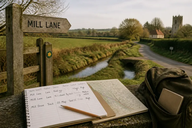
A place-name walk turns a familiar route into a set of clues you can check: a sign’s spelling, a word repeated across nearby lanes, or a name that changes between a map and a gatepost. The useful discipline is to record what you can see before deciding what any name means. A notebook, a map and a careful ear are enough to begin.
Choose a route that gives names room to repeat
Pick a compact area with several kinds of named features: a village street, a lane towards a field, a stream crossing, perhaps a common or a hill. Repetition matters more than distance. If the same element appears on a road sign, a public map and a local noticeboard, you can compare forms without treating any one source as final.
In eastern England, for instance, a walk might pass a settlement, a drainage channel and a low, open stretch of farmland. The names encountered need not share an origin; their closeness simply gives you a useful way to notice patterns. Avoid designing the route around a single dramatic theory, such as a supposed ancient boundary. That can make ordinary evidence look like confirmation.
Choose paths and streets where you can walk lawfully and stop without obstructing anyone. Mark a start and finish on a map, and note which sections follow public roads or rights of way. A route drawn with a pencil is like a shopping list: it keeps the outing focused, but it should not dictate what you have to find.
Compare three ways of collecting names
There are three useful approaches, each suited to a different kind of walk. You can work from visible signs, follow names already printed on a map, or listen for forms used in local speech. Combining them is often fruitful, but keeping their notes distinct prevents one source from quietly replacing another.
Sign-led recording suits a short, observable route
Start with road signs, fingerposts, building plaques and labels on public facilities. Copy the spelling and punctuation exactly, and note the object carrying it: a road sign is not the same kind of evidence as a handwritten notice. Add the direction you approached from, since a sign may show only a shortened form or a destination rather than a feature’s full name.
This approach works well for a first walk or a route with many marked junctions. Its limit is plain: signs are selective. A stream, field or old lane may have a locally used name without any sign at all.
Map-led recording suits close comparison
Use a paper map or an offline map application to identify named features before you set out. Record the map edition or source alongside each form, then check whether the name appears at the feature itself. Maps can preserve useful distinctions, but their labels may be abbreviated, shifted away from the feature or absent at a larger viewing scale.
This method is especially handy when names cluster around bends, crossings or parish edges. Mark the label’s position rather than assuming that the nearest object owns it. A name printed beside a watercourse, for example, might refer to the watercourse, a nearby settlement or a larger area.
Speech-led recording suits names that signs miss
If a resident offers a name in conversation, write down the words as heard and note the context in which they were used. Ask politely for a repetition or clarification if you did not catch the form. Do not press for a story about its origin, and do not treat one person’s pronunciation as a definitive local version.
This approach can reveal informal names and pronunciations that printed sources leave out. It also needs tact: people are not walking reference books, and a conversation should remain voluntary. If you are unsure whether to record a name linked to a private home or an individual, leave it out.
Keep the name, source and interpretation in separate columns
A simple field table helps keep observation apart from inference. Use one line for each encounter, even when you suspect two forms refer to the same place. That lets you compare later without smoothing away a spelling difference too soon.
- Recorded form: copy the letters exactly, including hyphens or apostrophes.
- Feature: note what the name appears to label, such as a lane, stream, field or settlement.
- Source: identify a sign, map, spoken use or other visible record.
- Position: mark the location on your route map or describe the nearest junction.
- Context: note the surrounding landscape or wording, without adding a cause.
- Confidence: distinguish a clear reading from a doubtful one, and explain why it is uncertain.
Say you find “Mill Lane” on a sign, then see “Milll Lane” handwritten on a nearby community notice. Record both forms, their sources and where you saw them; the extra letter could be a slip, a local variant or something else. The expected result is a usable comparison, not a verdict about which spelling is historically correct.
Repeated words are clues, not ready-made explanations
After the walk, group repeated elements: perhaps several names contain “ford”, “green” or “marsh”. First check whether the word is genuinely part of each name, rather than a nearby map label or a descriptive phrase. Then compare the features and their positions. A shared word can suggest a question worth asking, but it cannot by itself establish a shared origin or a connection between places.
Spelling variation deserves the same restraint. Older maps, current signs and spoken forms may differ because of abbreviation, copying, pronunciation or later standardisation. Those are possibilities, not conclusions. Keep every recorded form, and mark any proposed explanation as a question for later checking.
Useful next checks include comparing another map source, consulting a local place-name resource or asking a local archive what records it holds. If a source gives an early spelling, note exactly where it comes from rather than silently substituting it for the name you saw on the walk. Where a form is uncertain, say so plainly.
Which approach should you choose for your walk?
What should I bring on a sign-led walk?
Take a notebook and a map, plus a pencil for quick location marks. A phone camera can help capture public signs when appropriate, but write down the source and position as well; a photograph alone may lose its context.
How can I compare spellings without choosing a winner?
Transcribe each version exactly and record who or what displayed it, where it appeared and when you noted it. Compare the forms only after the walk, and label explanations as tentative unless a reliable source supports them.
Should I ask residents where a name came from?
You may ask whether a form is used locally, provided the conversation is welcome and the question is respectful. Treat an origin story as something to record with its source, not as settled fact; people may repeat different accounts of the same name.
How do I choose between signs, maps and local speech?
Choose signs for a short route with visible labels, maps for careful spatial comparison, and conversation when informal usage is your main interest. If you want a balanced record, use more than one source but keep each source identifiable in your notes.
End the walk with a record you can revisit
Back at home, transfer your route and notes while the locations are still clear. Keep uncertain readings marked, and distinguish direct observations from comments, map labels and your own questions. A modest record that preserves disagreements is more useful than a tidy account that erases them.
A place-name walk is most productive when it leaves room for uncertainty. Record what the sign says, where the map places its label and which words recur; let later sources address origin. That habit makes each new place-name clue easier to check, and keeps a plausible guess from becoming an accidental fact.